Notes from Tesla AI Day
Videos · Technology · Source
(This mostly covers the first half of the talk)
Tesla’s Neural Network Architecture for Vision
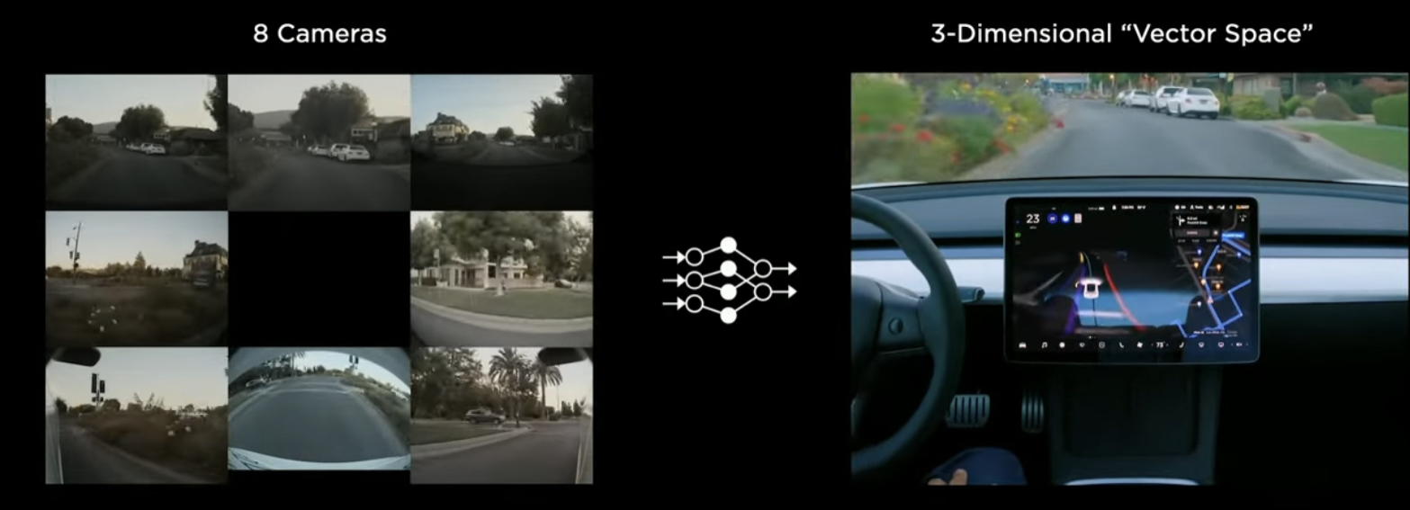
8 cameras on the vehicle. They send images in real time which are processed into a vector space ⇒ 3-dimensional positions of lines, edges, curves, traffic signs etc
It’s kind of represented below.
Kind of building a synthetic animal from the ground up. Car senses the environment and moves around autonomously. Building all components in-house:
- Mechanical components (the body)
- The Nervous system (electric components)
- The Brain (the synthetic visual cortex)
The old way
4 years ago, all the processing was only on an individual image level. Each image then made a piece of the vector space
Pre-processing and regnets
Light hits the camera. Sent as a 1280x960 12Bit (HDR) @ 36Hz
Then, there is a feature extraction backbone. Use residual NNs for this (regnets)
There is a stem, and a number of residual blocks connected in series
Regnets are great, because they allow you to trade-off latency vs accuracy
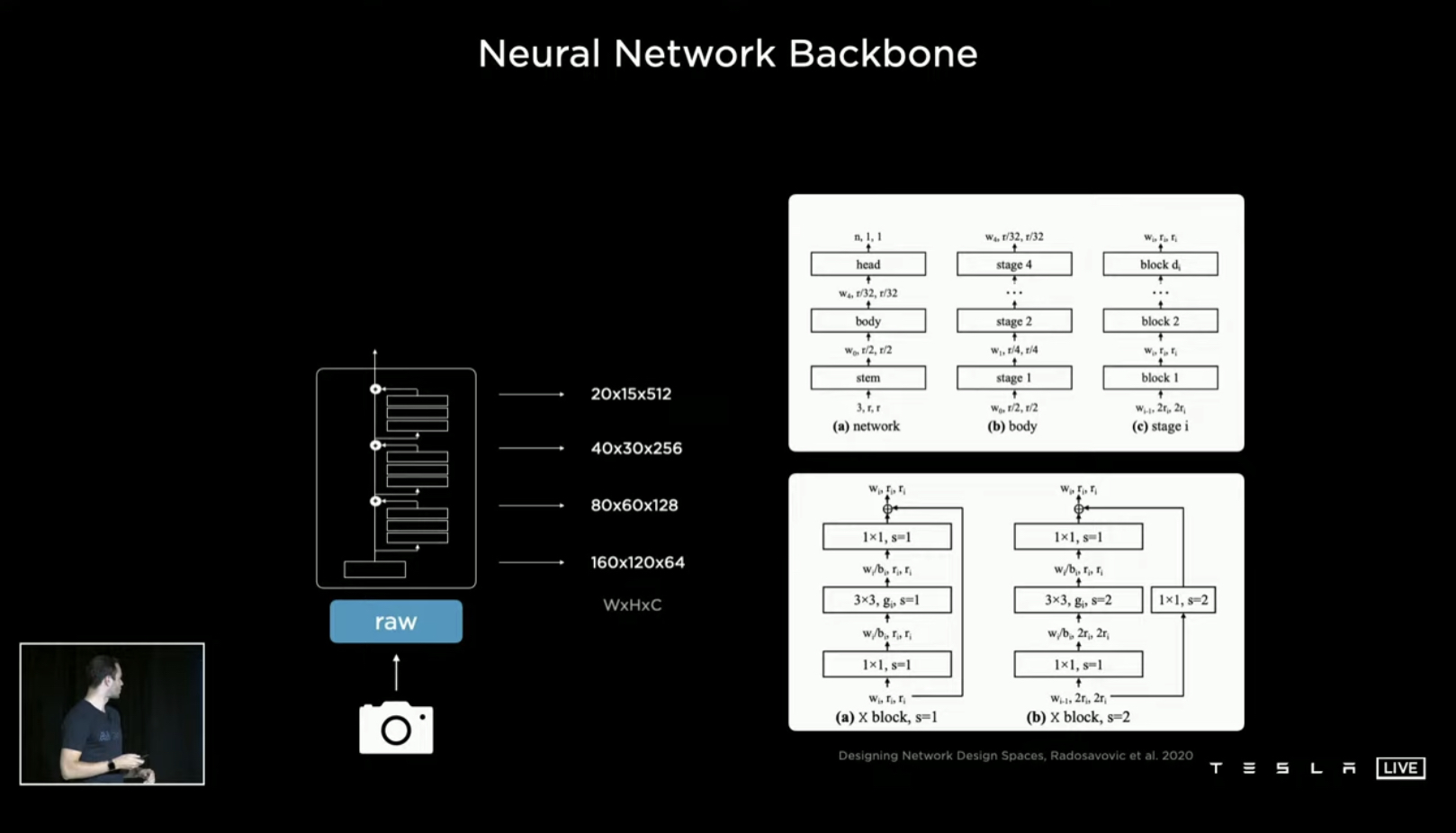
Regnets give a number of features at different resolutions and scales as outputs
At the bottom of the hierarchy in the image above, we have very high resolution (spatially) information with low channel counts — neurons here are really scrutinizing a small part of an image. At the very top, we have low resolution information (spatially) with high channel counts — neurons here are able to see a lot more of the image and get more context
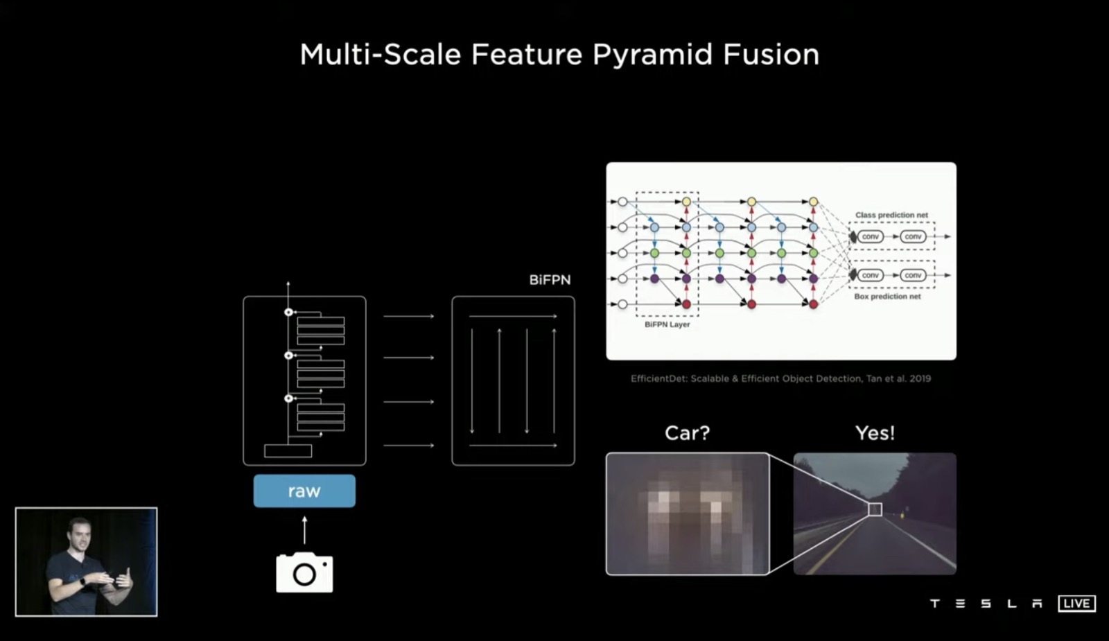
Feature Pyramid Networks
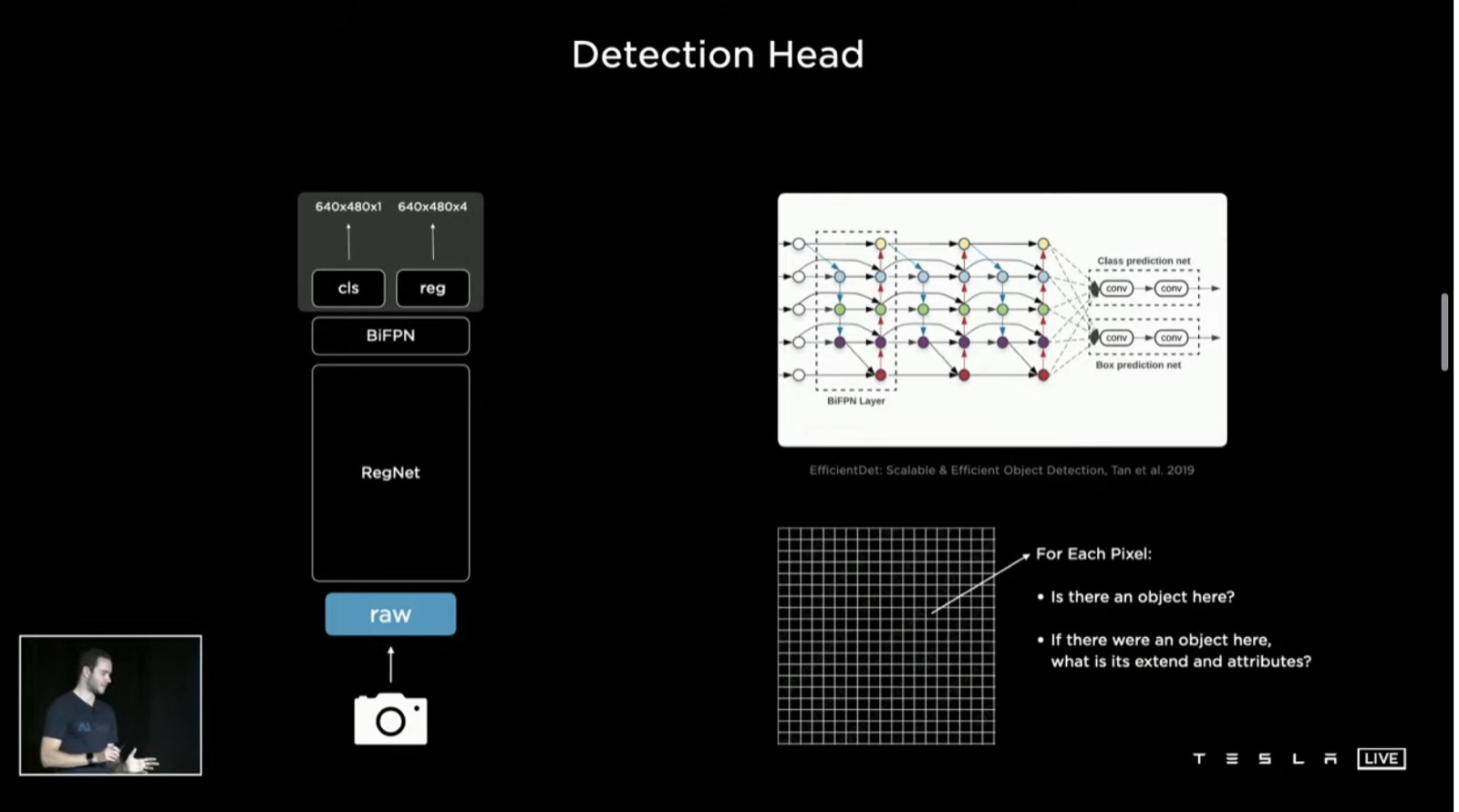
After this, process these features with feature pyramid networks (BiFPNs here). They get multiple scales to talk to each other effectively and share a lot more information. For example, if you’re a neuron all the way down in the network and are looking at a patch and trying to figure out whether it’s a car or not – it helps to know what the top layers are telling you (for example, that you’re on a highway. This gives you a lot more context behind what’s going on
Detection heads
After a feature fusion across scales, we then go to task specific heads. For example, there’s a one-stage YOLO-like object detector where you initialize a raster, and there’s a binary bit per position telling you whether or not there’s a car there. In addition to that (if there is a car), it also tells you a bunch of other attributes that you may be interested in (x,y with height offset, what kind of car it is etc)
Multi-task learning (Hydranets)
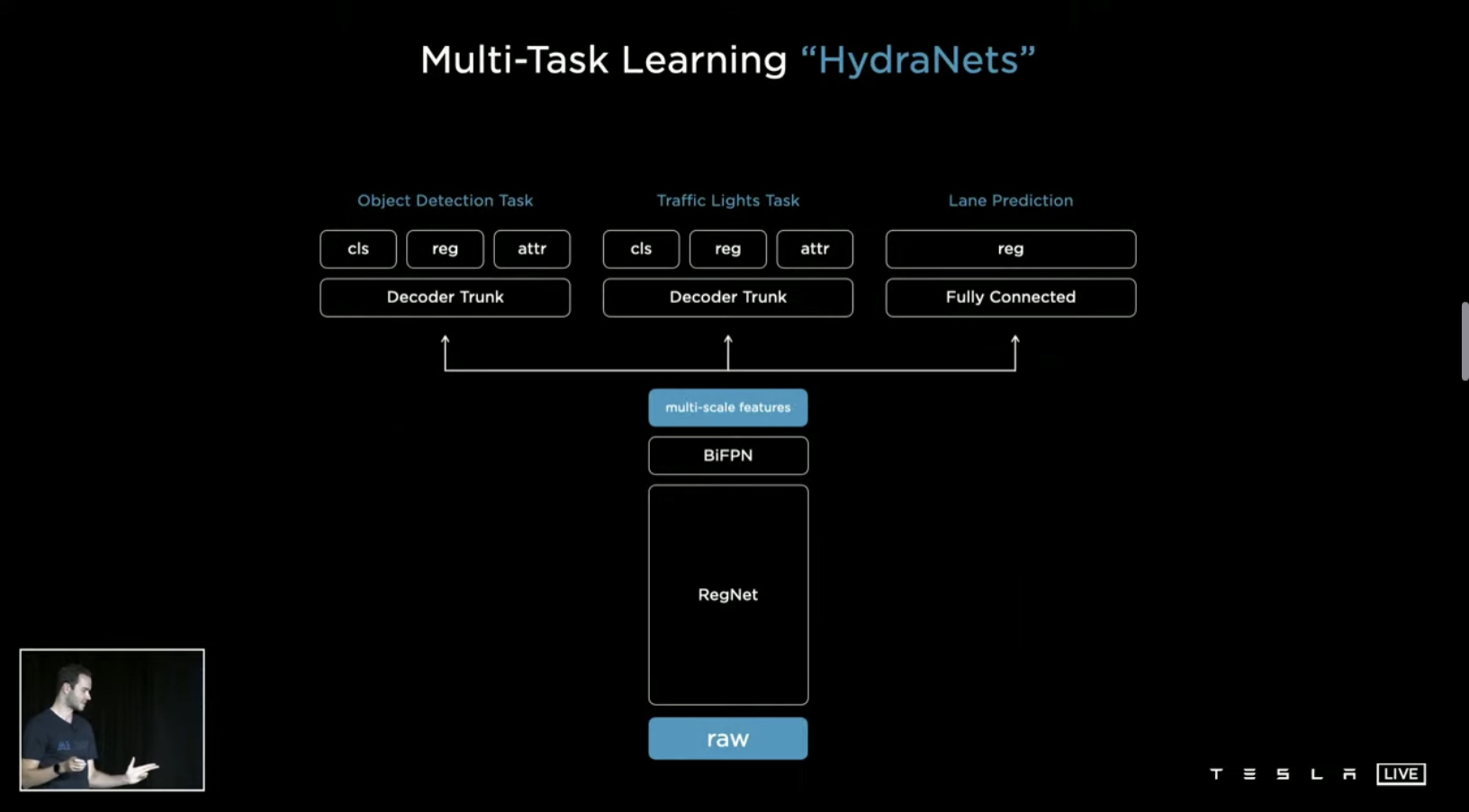
Discovered that they didn’t just want to detect things just once – wanted to do a large number of tasks instead (and ideally in parallel) – there’s a common-shared backbone, which then branches off into a number of heads (call these Hydranets)
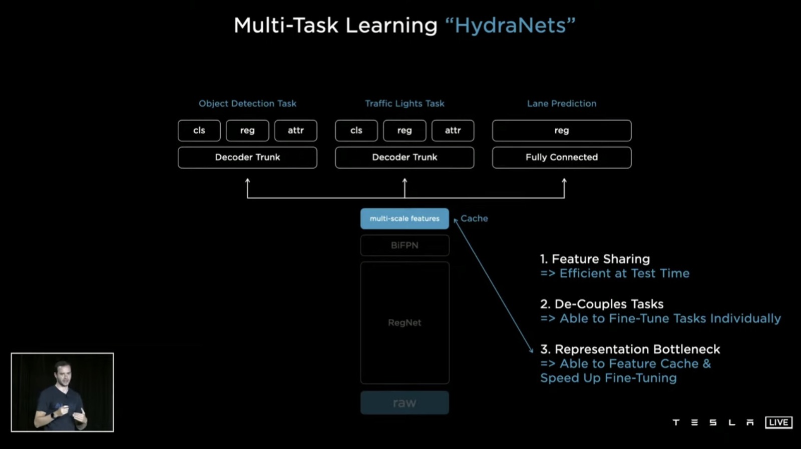
This architecture has a number of benefits:
- Because of feature sharing, we can amortize the forward pass inference at test time. So this becomes very efficient to run
- De-couples tasks — we can work on and fine-tune each task in isolation without impacting any of the other tasks. Makes debugging and iteration much faster
- Because there’s a bottleneck in the features at the “multi-scale features” stage, can cache features to disk here. This significantly speeds up training and fine-tuning
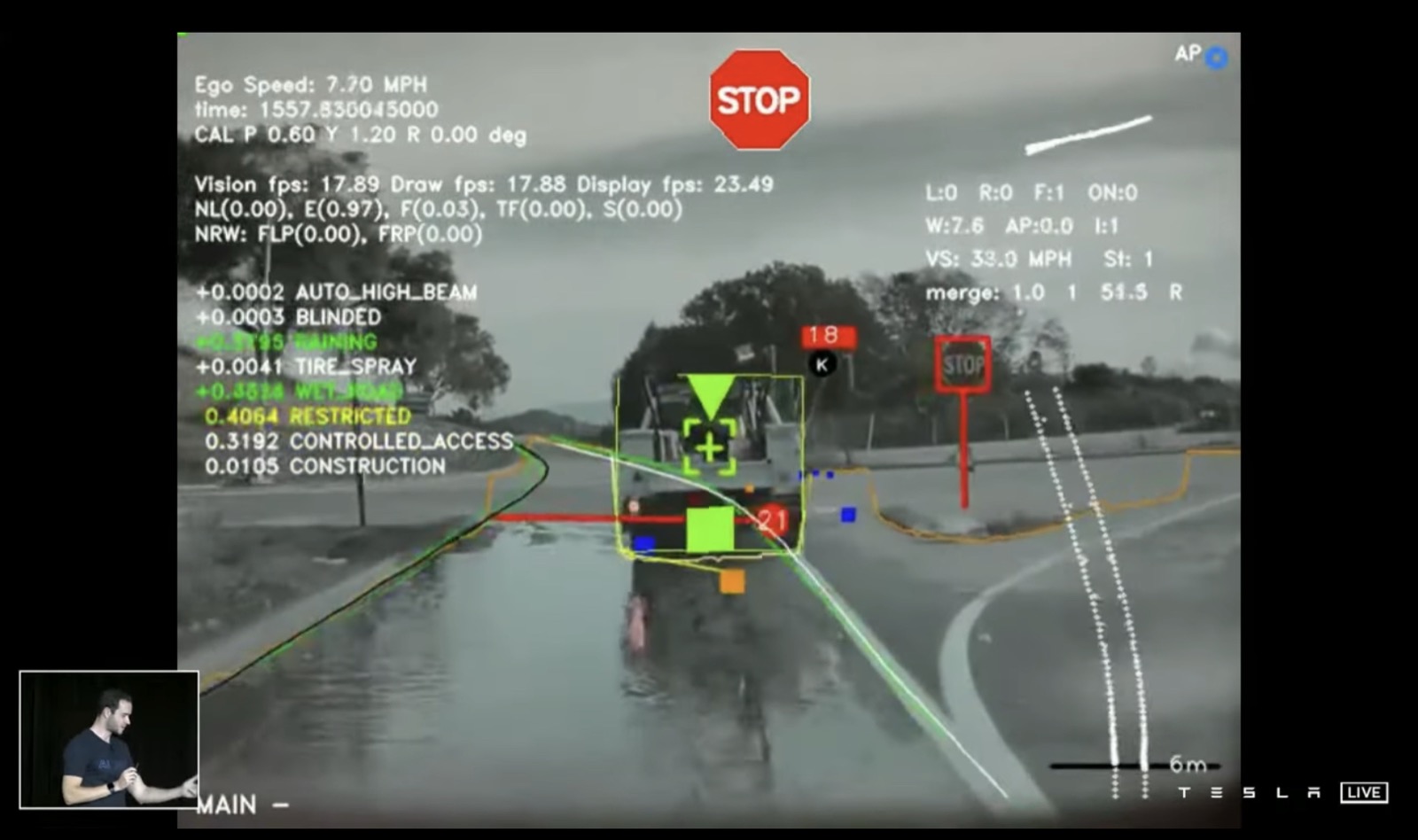
Were obtaining these kinds of predictions around 4 years ago from a hydra net
Problems with the old way
This wasn’t sufficient for full scale autonomous driving. You can’t just drive based on image-scale predictions. You actually need to project them into some kind of vector space around you
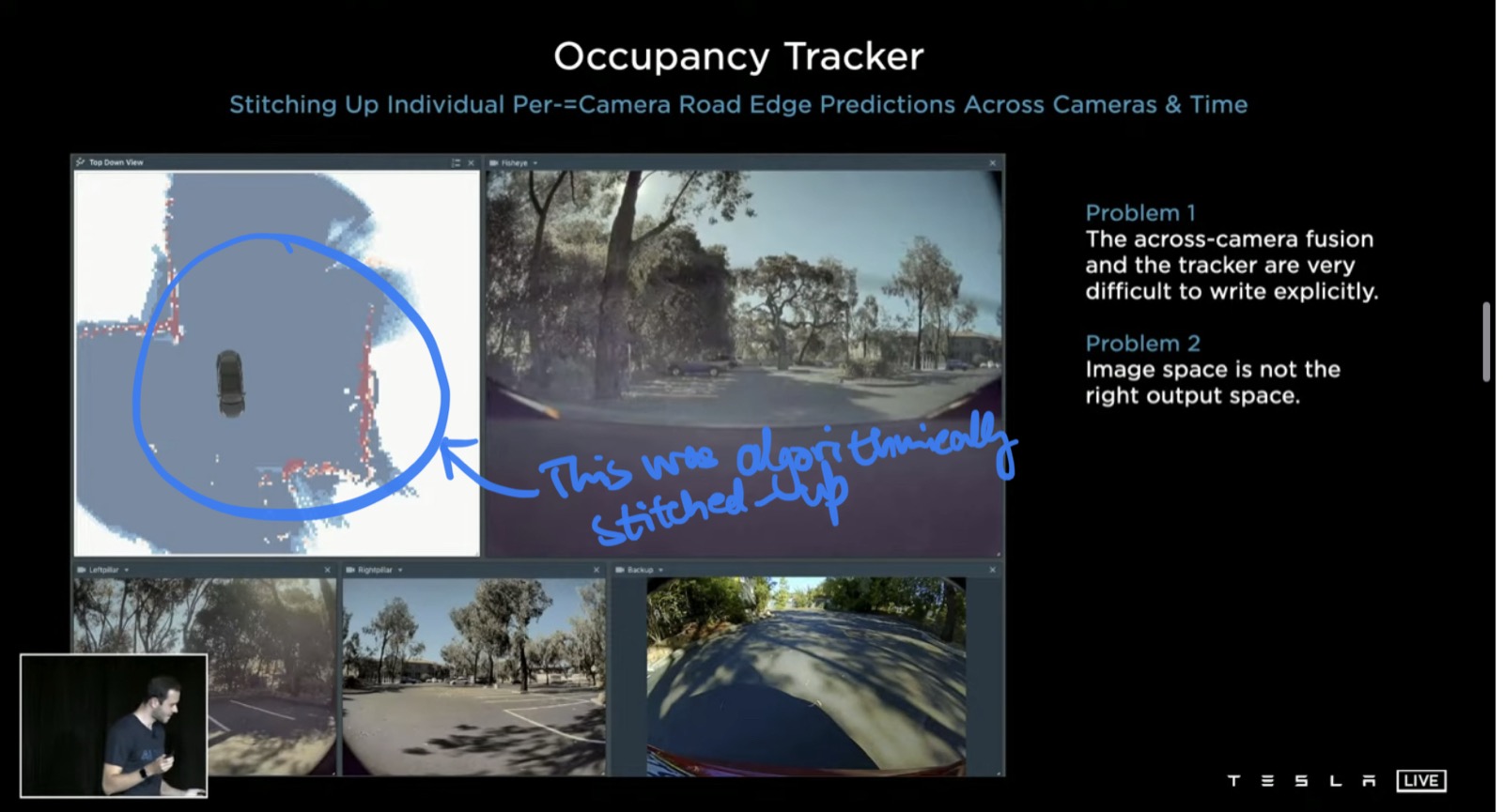
Tried to do this using C++ and developed something called the Occupancy Tracker
But there were two problems with this:
- Across-camera fusion and trackers and extremely difficult to write explicitly. Instead of writing them explicitly, you should have them as a part of the neural network and train everything end-to-end
- The image space is not the right output space. You don’t want to make predictions in the image space — you want to make them directly in the vector space
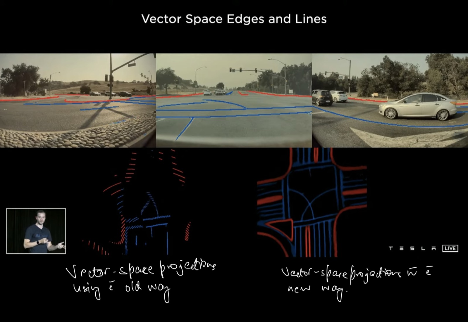
An example of this problem is below. Things that look great in the image space look haywire in the vector space
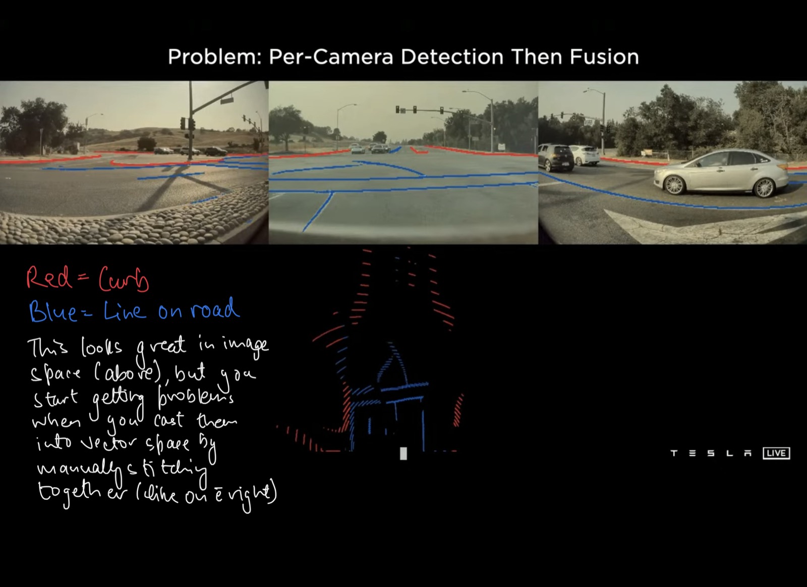
The reason for this is that you need to have an extremely accurate depth-per-pixel in order to to accurate vector projections. But real-life cameras being what they are – it’s really hard to have per-camera detection followed by fusion. Also, if there’s any occluded areas where you would like to make predictions, you would not be able to.
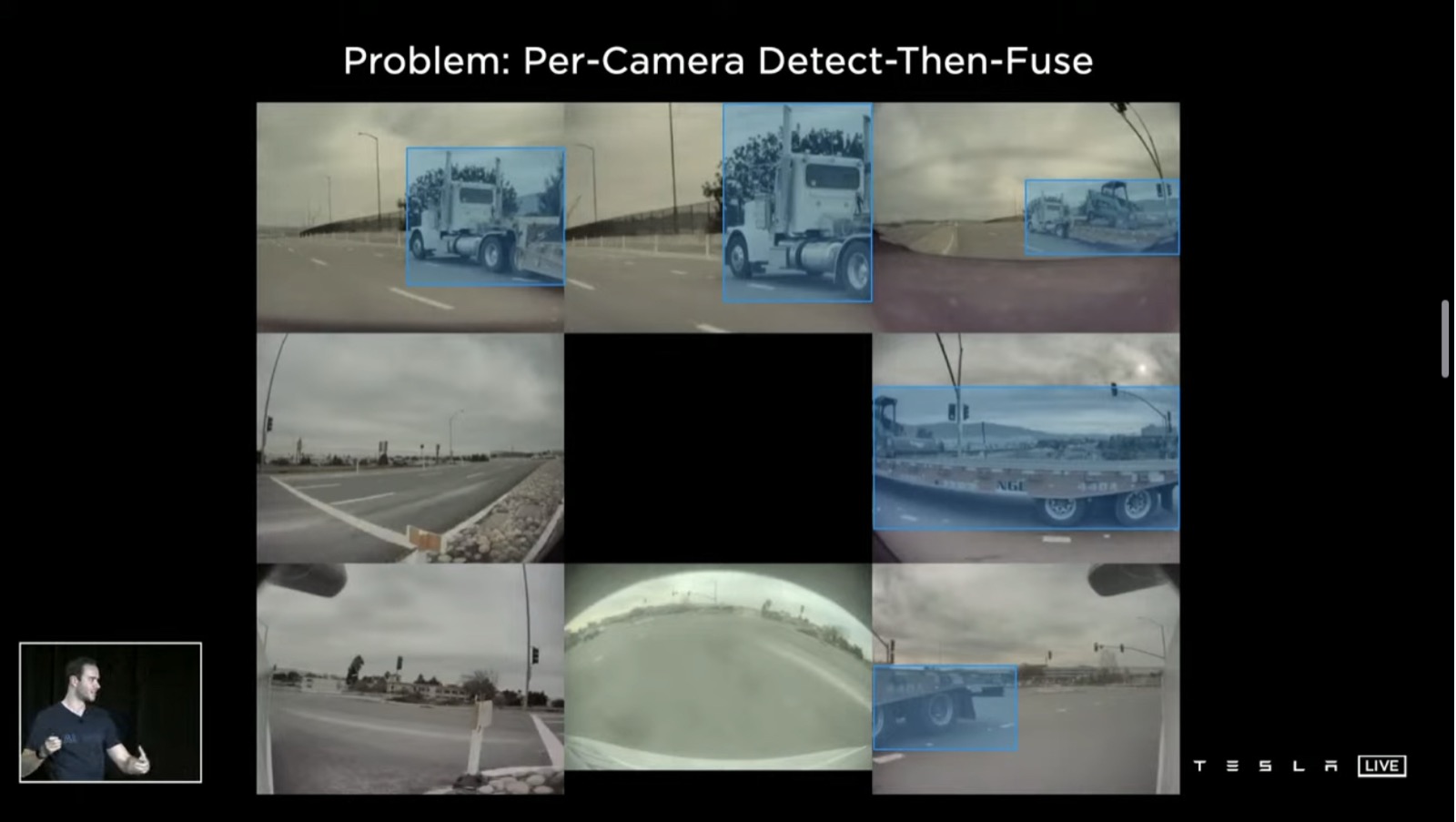
Another problem is that if there’s an object that spans multiple cameras (like the truck in the image below) – since no camera is able to see the entire object, you will not be able to make proper predictions on that object
Solution: Multi-camera vector space predictions
Take all of the images, simultaneously feed them into a single neural net, and directly see the output in the vector space
This is hard to achieve. But roughly, you process images from every single camera into a backbone, then somehow fuse them, and then represent the image-space features directly as vector-space features, and then go into the decoding in the head
Two problems with this:
- How do you transform features from image-space to vector-space?
- If you want vector-space predictions, you need vector-space datasets. Labelling the images is not enough — you need vector space labels. How do you do that?
Problem 1: Transforming features from image-space to vector-space
In the vector space, we’re trying to have bird’s eye view predictions instead of image space predictions. If we focus on a single pixel in yellow in the image below, the pixel might be trying to decide “am I part of a curb or not”?
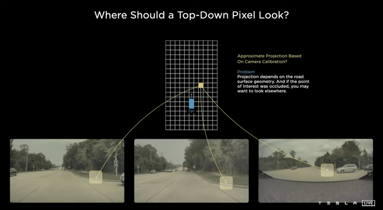
We know roughly how the cameras are positioned, so we can roughly project this point in the camera images
The evidence for whether this point is a part of the curb may come from somewhere in these images
But this projection is really hard to get correct. It’s a function of the road’s surface (is it sloping up or down?). And there could be other data-dependent issues, like occlusion
To solve this issue, use a transformer to represent this space and learn where to look end-to-end, using multi-headed self-attention
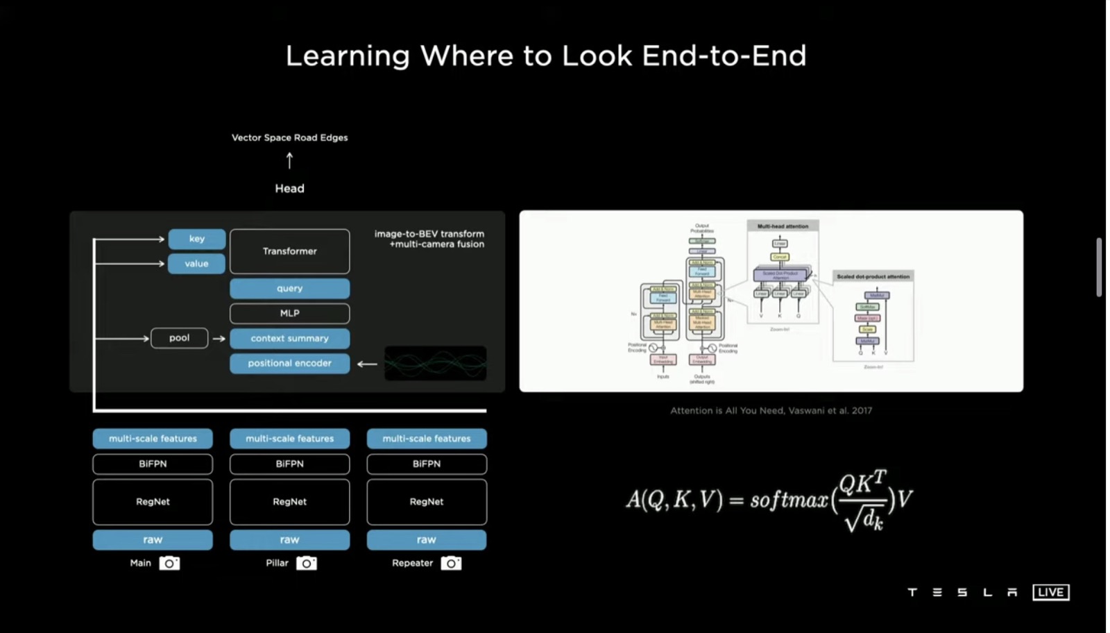
Effectively, this initializes a raster of the size of the output space that you would like. Then, you tile it with positional encodings. These get encoded (using an MLP) into a set of query vectors
All the images and their features emit their own keys and values. The query’s keys and values then feed into the multi-headed self-attention
Effectively, what’s happening here is that every single image piece is broadcasting in its key what it’s a part of. “I’m a part of roughly this location and I’m seeing this kind of stuff” — that’s in the key.
Every query is on the lines of “I’m a pixel in the output space in roughly this location, and I’m looking for features of this type”
The keys and the queries then interact multiplicatively, and the values get pooled accordingly
Problem 2: Calibrating the camera
You also need to normalise for the camera calibration. Transform all images into a synthetic virtual camera. This improves the performance a lot
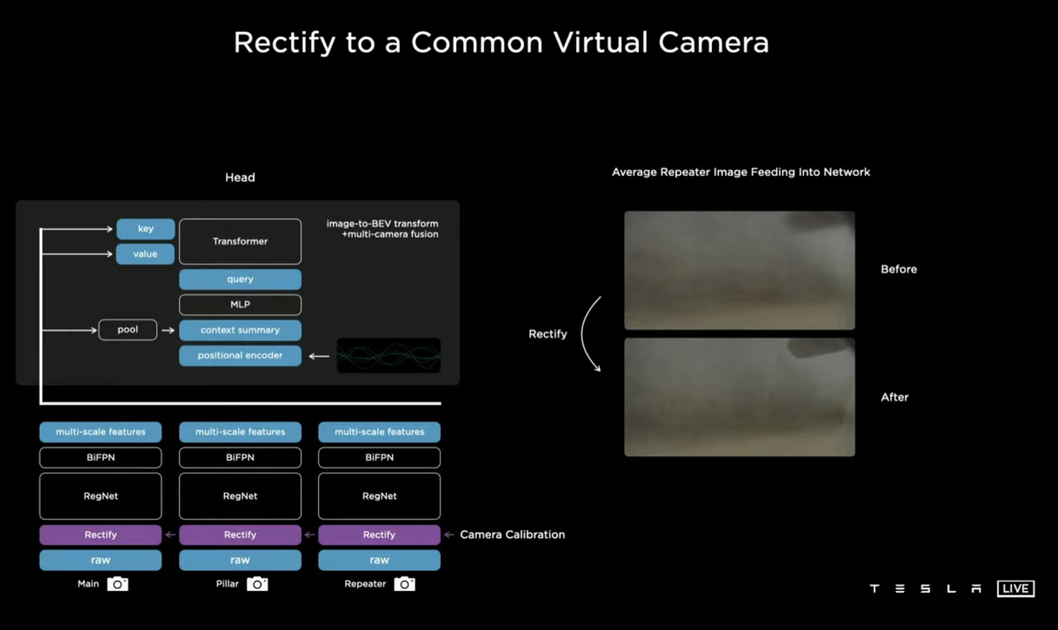
Before and after, once these problems were solved!
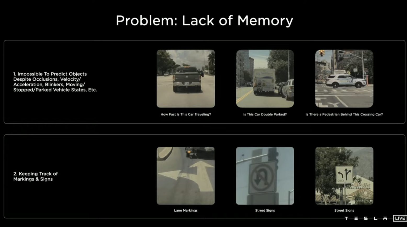
New Problem 3: Lack of memory
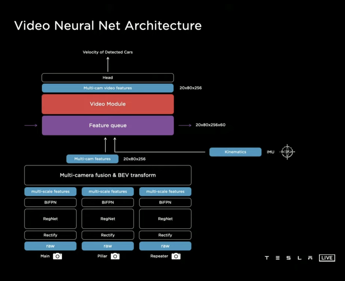
Often, you need a video (i.e., multiple images) — a single image won’t do. This can cause you to run out of memory
To solve this, created a video neural net architecture. This has a feature-queue module that caches some images over time, followed by a video module that fuses these images temporally
Feature Queue
Basically concatenate the features and positional encodings over time
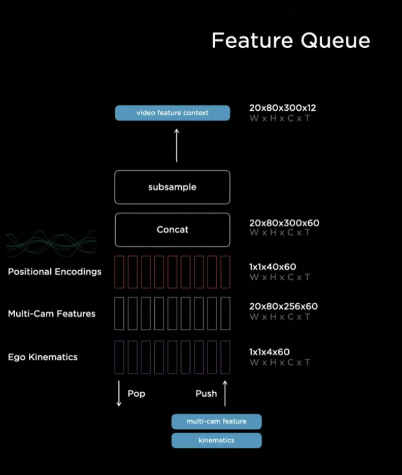
When do you enter features into a queue?
- A time-based addition of features (say, every 50ms) — needed to make sure we stay clear of temporary occlusions and can react to new features
- In addition to a time-based queue, also need to have a space/distance based addition (say, every 1 meter travelled) — needed to make sure you can update signs and markings on the road, as well as changes to the road geometry (specially when you’re stuck at a red light)
Video Modules
Looked at multiple options. 3 Dimensional CNN, Transformers (including Axial Transformers — to make them more efficient), RNNs of different kinds …
Eventually, settled on a spatial RNN for the video module
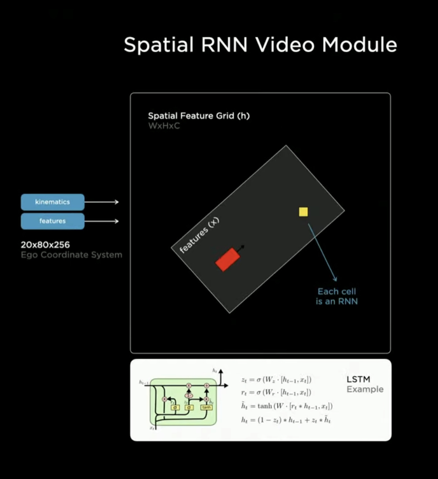
The structure of the problem is that you’re driving on 2-d surfaces. So you can structure it as a 2-d matrix
These significantly improve robustness to temporary occlusion, and improve ability to estimate depth and velocity
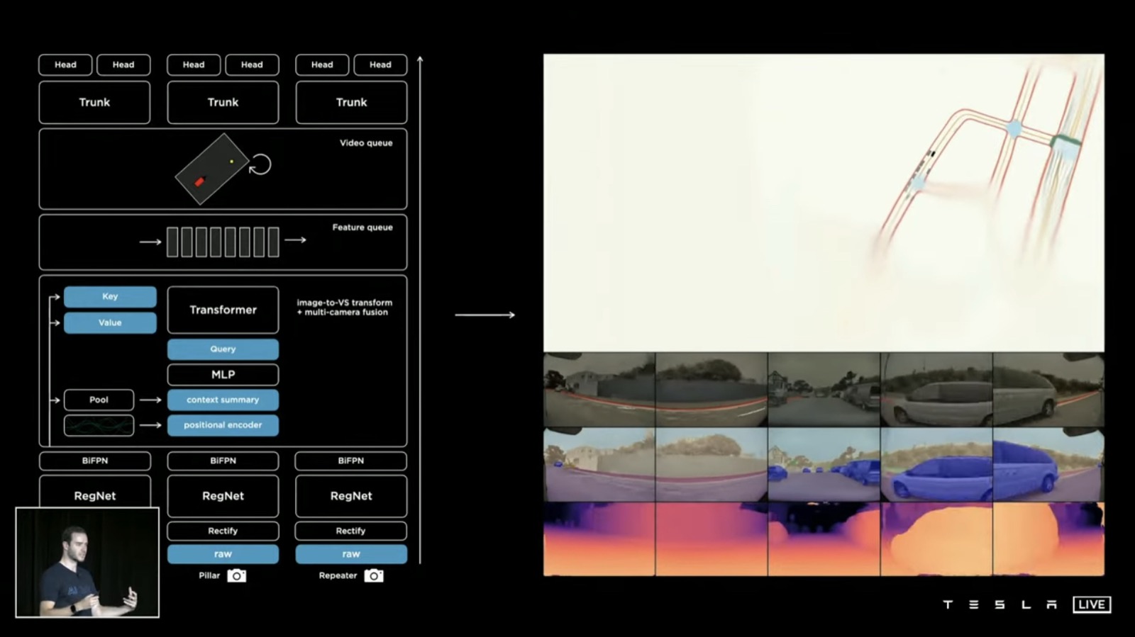
Current architecture
What the complete model looks like now:
Potential improvements
Fusion of time and space is pretty late right now. Maybe can do an earlier fusion?
Outputs are dense rasters and its pretty expensive to process these dense rasters, which is bad given the latency requirements. How can this be done faster?
Planning and Control Architecture
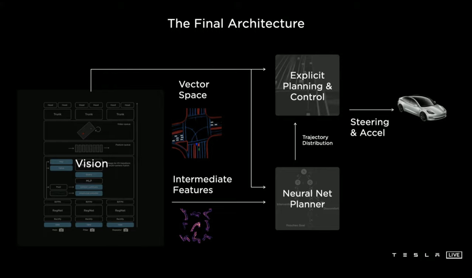
The Vision Network takes in data and compresses it down into a vector space. Once this is done, the planner then consumes this vector space, and gets the car to its destination while attempting to maximise:
- Safety
- Comfort
- Efficiency
Key Problems in Planning
The Action Space is non-convex (if you use discrete search, this won’t happen. But if you use a continuous function optimisation, our planner can often get stuck in local minima) and high dimensional (if you use discrete search, this will be computationally intractable)
Solution
Use a hybrid planning system. First, use a coarse search method to crunch down the non convexity and come up with a convex corridor that the car could move through
Then, use continuous optimisation to come up with a final, smooth trajectory through the convex corridor
Generating datasets
Manual Labeling
Working with a third-party for critical datasets is just not going to cut it. The latency of working with a third party is extremely high, and the quality is often not amazing
Brought all the labelling in-house. The data labelers are in the US and colocated with the engineers. Built their own data labelling infrastructure to assist the labelers
Auto labeling
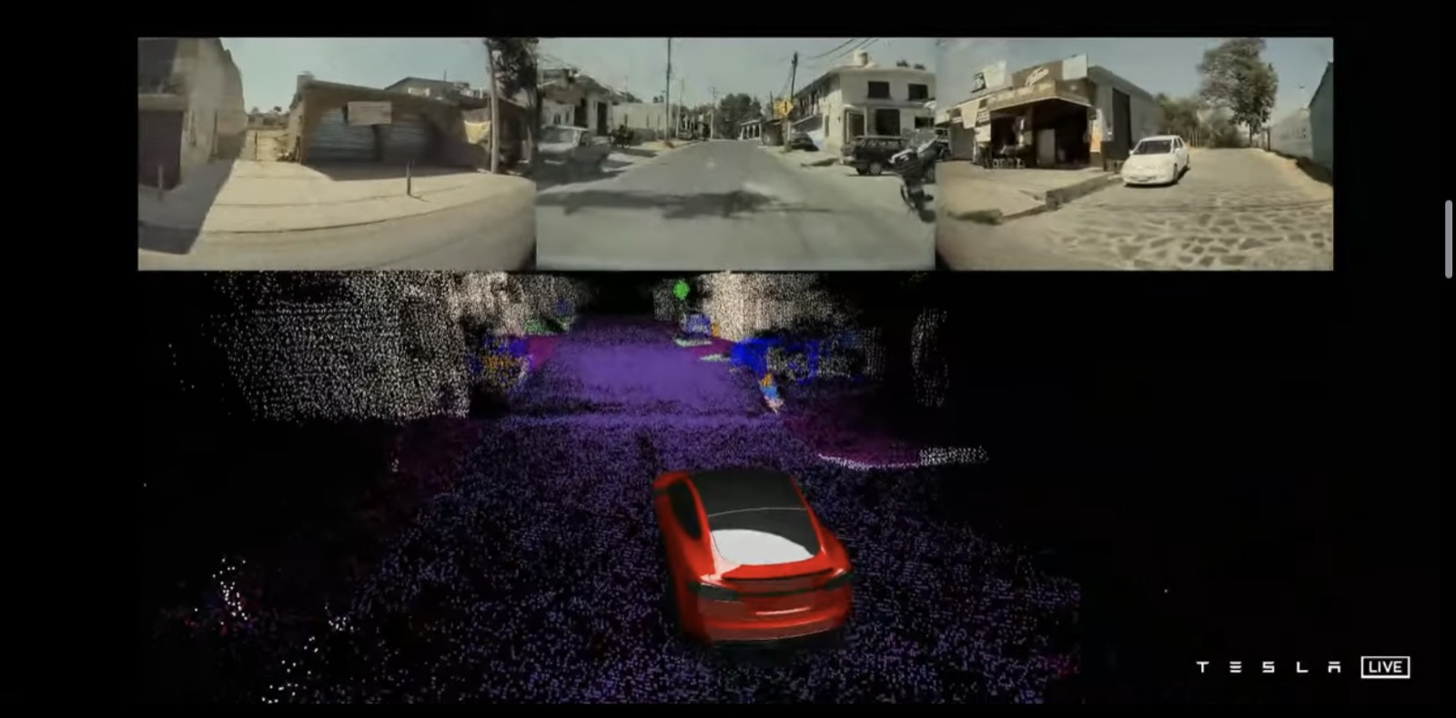
Run neural networks offline (in the cloud) on data that is collected, and create segmentation maps, depth estimation, point matching etc
CAN CREATE 3D MODELS WITHOUT LIDAR, BECAUSE SO MANY CARS HAVE DRIVEN PAST AN AREA!
Simulations
Can use both manual and auto labels to create really great, high-fidelity simulation models!
You can use then these to both study failures, and study how a new algorithm update might behave in the real world before pushing out an update
Scaling data generation and simulation
Thousands of GPU, 20000 CPU cores, and 2000 actual self-pilot computers are connected in a cluster
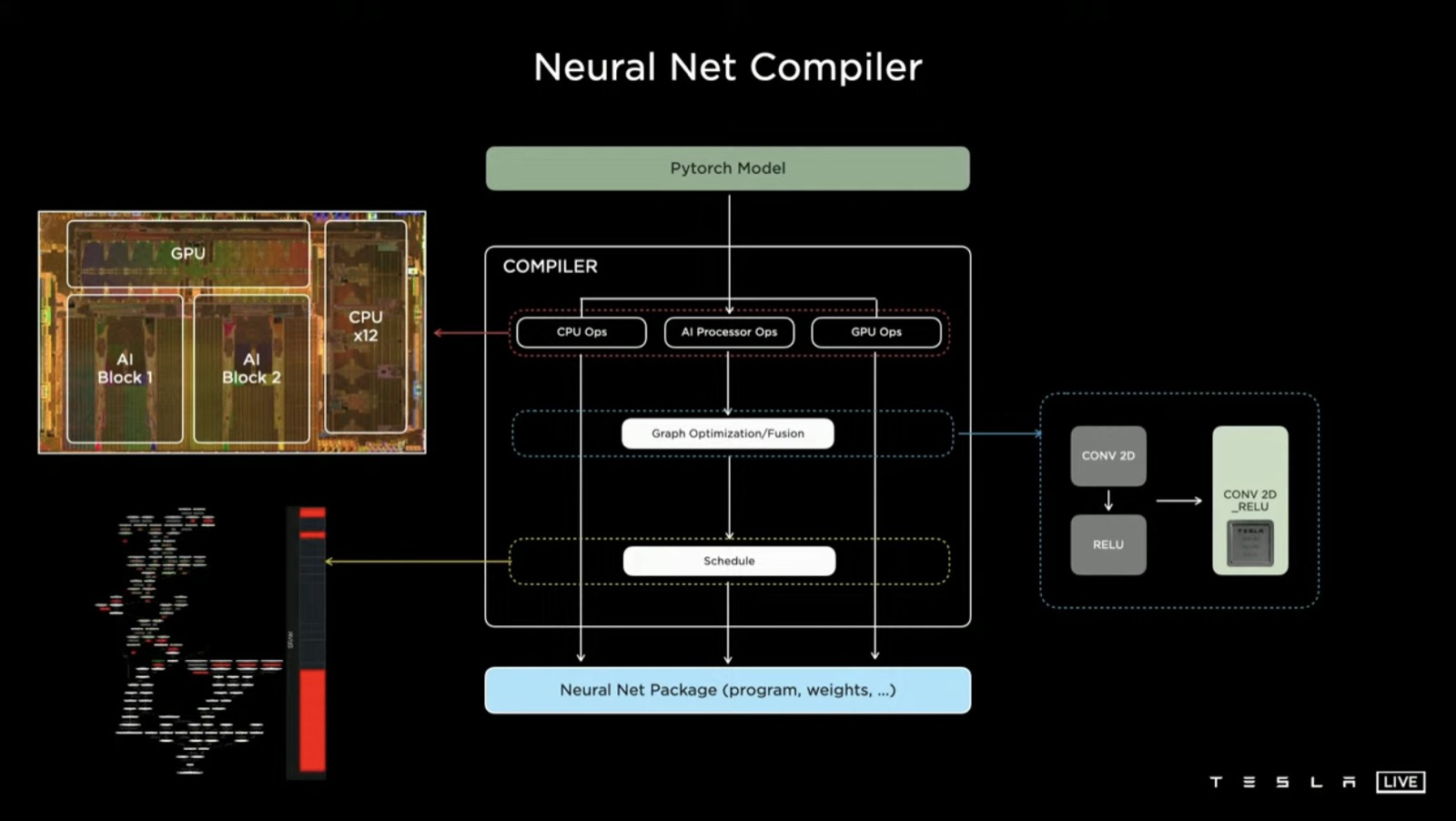
Running it in the Car: AI Compiler and Scheduling
Objective: minimise latency and maximise frame rate